WinFence can be used to graphically create detailed, full-color, cross-sections and fence diagrams quickly and easily. The program can be used to interpret and map soil and rock layers, contamination, fossils, minerals and hydrocarbons.
The WinFence cross-section extension module of StrataExplorer can be used to quickly create detailed full color cross-sections.
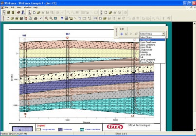
A wide variety of strata can be used to create cross-sections. Depending on the industry, types of strata that can be used include layers, faults, lenses, intrusions, and alteration zones (mineralization, contamination, hydrocarbons, shear strength). Very detailed and complicated stratigraphy can be represented and easily drawn.
This module shares the same database as the boring log module and can be used to access and plot the boring/well data. A wide variety of boring/well data can be plotted on the cross-sections; including lithologic symbols, sample symbols, core logs, well diagrams, graphs, and geophysical logs.
There is the option to have the program automatically generate the cross-section using artificial intelligence (AI) built-into the program. When determining how to connect the strata between boreholes, wells, and intersecting cross-sections the program looks at the similarities in the lithologies, thicknesses, and occurrence of the strata. This methodology works well with most geologies; except, where the geology is very complicated or there are faults.
A unique snapping approach can be used to add layer, alteration zone, intrusion, and lense boundaries. This approach allows the boundary of one strata to be fixed to the boundary of another strata. Making the input of strata boundaries quick and accurate. Boundaries can be partially drawn and partially snapped. Snapped boundaries can include one or more different strata. In addition to snapping, strata boundaries can be assigned to the strata above or below.
After the cross-section has been created, the strata boundaries can be used to create contour maps in the contouring and gridding module. In addition, the cross-sections can be displayed in 3D as fence diagrams.
Comments